Drone Map 2.0 - 無人機空域查詢
Category : Travel and Navigation
Author Name : Drone Map - 無人機行動服務
Operating System : android
License : Free
Rating : Everyone
Drone Map 2.0 - 無人機空域查詢 Download Links for Android
Drone Map 2.0 - 無人機空域查詢 Screenshot
About Drone Map 2.0 - 無人機空域查詢 Android Application
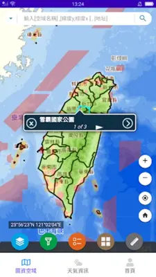
Drone Map 2.0 - 無人機空域查詢 is a map information query system managed by the Civil Aviation Administration and local governments in accordance with aviation laws. It provides information on restricted and prohibited areas for drone flights, including those announced by the Civil Aviation Administration, local governments, and relevant competent authorities. Government agencies, schools, or legal persons must obtain permission before operating drones in prohibited or restricted areas. The system allows users to query specific locations or areas and view detailed information about flight restrictions.
Application Official Website
https://drone.caa.gov.twApplication Support Email
[email protected]Application Main Features
- Operated by the Civil Aviation Administration and county and city governments.
- Image information is imported for reference only.
- Range or area disclosed does not exclude other laws and regulations.
- Three categories of prohibited or restricted areas.
- Government agencies, schools, and legal persons need consent for activities in prohibited or restricted areas.
- Contact information for relevant competent authorities available in remote control drone management information system.
- Operator shall comply with Civil Aviation Law and Regulations for the Administration of Remote-controlled Drones.
- Detailed information can be browsed by clicking on the map or entering address or latitude and longitude.
- Map information query system is based on information announced until December 28, 2011.
Application Ratings
The content is rewritten by Gemini Ai ,Published Date : 24/3/2024 , Modified Date : 24/3/2024


